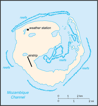
Europa Island is an island of French possession since 1897. The island is heavily wooded, and is the site of a
small military garrison that staffs a weather station!
Europa Island is in Southern Africa, it is located in the Mozambique Channel, about one-half of the way from Southern
Madagascar to Southern Mozambique. There is a total of 28 square kilometers of land, with small lakes and ponds dotting
the land. Europa Island is about 0.16 times the size of Washington D.C. There is 22.2 kilometers of coastline on Europa
Island.
The climate of Europa Island is tropical. The terrain of Europa Island is low and flat. The lowest point
on Europa Island is at the Indian Ocean, 0 meters. The highest point on Europa Island is 24 meters, and there is no name
for this location. 100% of the land is used for other uses. Very little of land, if any at all, is used for permanent
crops or arable land.
Europa Island is a wildlife sanctuary. There are no indigenous inhabitants, but there is a small French military
garrison and a few meteorologists on Europa Island. Europa Island is commonly visited by scientists.
Europa Island's conventional short form is Europa Island. The local short form is Ile Europe. Europa
Island is a possession of France, and is administered by a high commissioner of the Republic, resident in Reunion. The
law's of France, where applicable, apply. The flag of France is used for the flag of Europa Island. Communications
of Europa Island include one meteorological station. There is one airport on Europa Island.
Defense of Europa Island is the responsibility of France. One international dispute exsists with Europa Island.
This dispute is Madagascar also claims Europa Island as their own.